![Item #3729 [Pre-Flood Aerial Photo-Map of Kootenay Region, B.C.] Columbia River Developments : Arrow Lakes Project, 1960. B C. Hydro, Power Authority - Land Mosaic.](https://harropianbooks.cdn.bibliopolis.com/pictures/3729.jpg?width=768&height=1000&fit=bounds&auto=webp&v=1617565656)
![[Pre-Flood Aerial Photo-Map of Kootenay Region, B.C.] Columbia River Developments : Arrow Lakes Project, 1960](https://harropianbooks.cdn.bibliopolis.com/pictures/3729_2.jpg?auto=webp&v=1617565656)
![[Pre-Flood Aerial Photo-Map of Kootenay Region, B.C.] Columbia River Developments : Arrow Lakes Project, 1960](https://harropianbooks.cdn.bibliopolis.com/pictures/3729_3.jpg?auto=webp&v=1617565656)
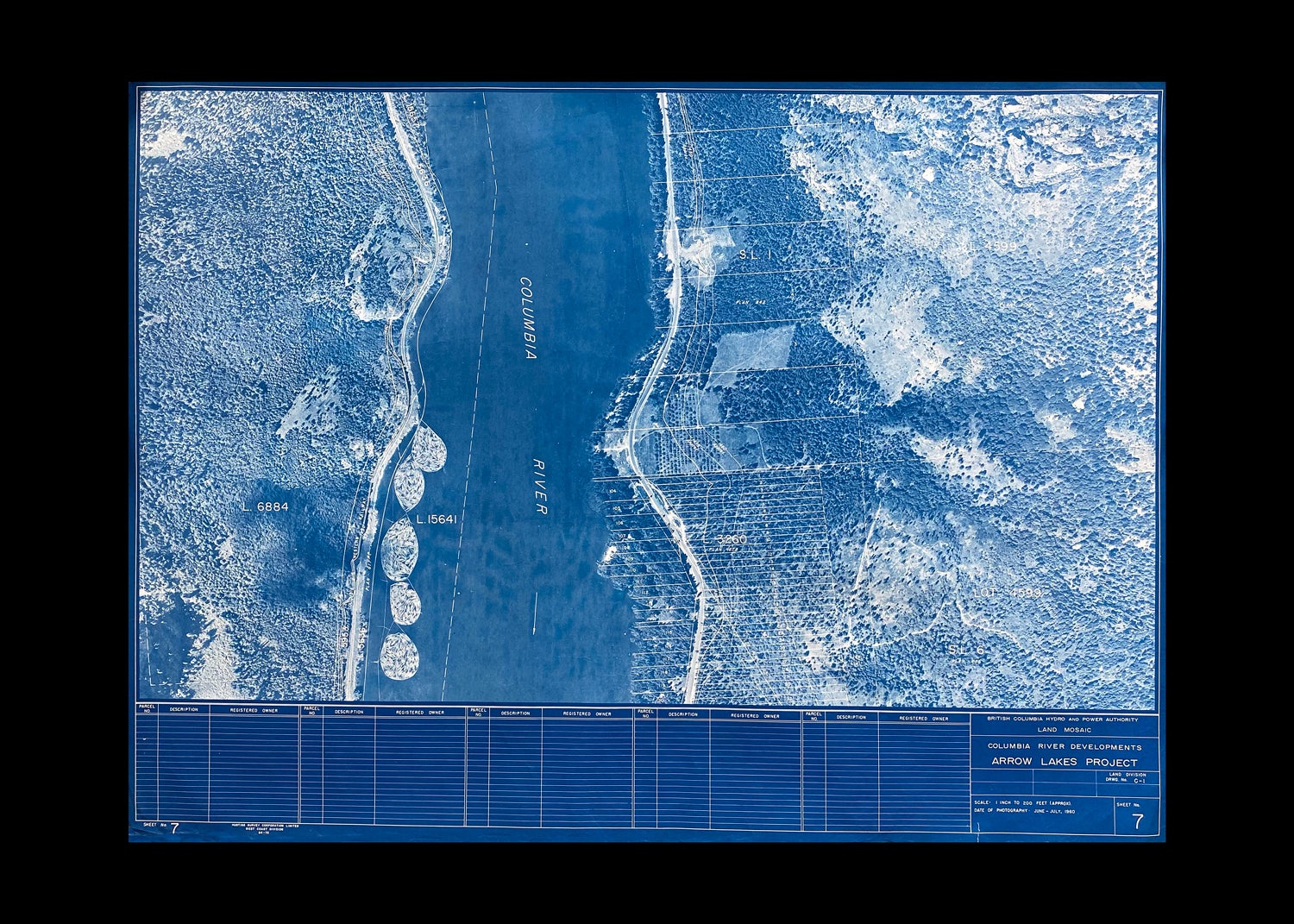
[Pre-Flood Aerial Photo-Map of Kootenay Region, B.C.] Columbia River Developments : Arrow Lakes Project, 1960
British Columbia: B.C. Hydro, 1960. Sheet Map. Sheet No. 7 - with "Hunting Survey Corporation Limited / West Coast Division" printed at lower left margin - in B.C. Hydro's Columbia River Developments : Arrow Lakes series having "Date of Photography June-July, 1960" stated at bottom right hand corner. Large photo map has a scale of 1 inch to 200 feet, so offers an excellent view of the properties about to be flooded near Robson, B.C. Note that the "Columbia River" is now designated as Lower Arrow Lake on most maps. A circa 1960 Aerial Photo-Map of Robson, B.C. measuring overall, 26 inches tall x 35-3/8 inches wide, the printed area within the single border/neat line measures 25 inches tall x 24-1/4 inches wide. Map with light edge wear and a few short closed tears, else clean and unmarked. Previously rolled. At Least Very Good. Item #3729
This aerial photo was produced by BC Hydro prior to the construction of the Hugh Keenleyside Dam (originally named the High Arrow Dam) the photos were then made into maps showing predicted flood elevations, propertry lines and where the flood levels would rise to after closing the gates. A large, historic aerial photo that allows many family properties to be seen prior to being submerged. "Originally two lakes 14 miles apart, the Arrow Lakes became one 230 km long lake due to the reservoir created by the 1960s construction of the Keenleyside Dam; at low water the two lakes remain distinct, connected by a fast-moving section known as the Narrows. Damming the Lower Arrow Lake resulted in water rising 12 metres above natural levels. As a result of higher water, the valley lost 2/3 of its arable land. Thousands of people relocated." wiki accessed 04/21.
Price: $325.00 CAD other currencies